
Johnson County Previous Residents by Era
Different records hold different slices of an address's past. Start with the current parcel to establish the legal description, then select the source that fits the period. A Johnson County deed chain follows ownership. Directories and telephone books can place occupants or contacts at a printed address. Census, obituary, probate, and newspaper work can add household or life-event context. The table separates those functions so a past-resident search does not turn a single listing into an unsupported claim about who lived in a house.
| Source | Years it covers | Where held | What it can show |
|---|---|---|---|
| County Clerk official-record index | Reported full index from 1852; confirm exact book or year | Online County Records, clerk terminal, or request route | Transfers, parties, document dates, legal descriptions, liens, and plats. |
| Cleburne directory transcription | 1899-1900 | Portal to Texas History / Johnson County Genealogical Society item | Address, residence or boarding notation, occupation, and employer clues. |
| Cleburne directory shelf | 1921, 1938, 1947 | Texas State Library city-directory holdings | Verified shelf years; confirm availability before a visit. |
| Cleburne-area telephone directories | 1908-2005, with gaps in the documented run | UT Briscoe Center directory index | Telephone and address-era context, not occupancy proof. |
| Federal census and newspapers | Census through 1950; local newspaper runs vary | NARA routes, local history archive, and UNT collection | Household context, notices, obituaries, and address changes. |
For a recent change, begin with the parcel and recorded transfer. For an older address, add printed directories, newspapers, Sanborn maps, and the census. If the web search stops, the County Clerk counter and public terminals, the Texas State Library microfilm finding aid, the Cleburne Public Library, and the Historical Commission are documented alternatives rather than dead ends.
Start a Johnson County Past Resident Trail
Begin with the present-day property in JCAD eSearch. Record the situs address, property or geographic ID, legal description, subdivision or neighborhood, assessed owner, and mailing address. The situs identifies where the parcel is. The mailing address tells the appraisal district where tax correspondence is sent. Those values may agree, but they should not be treated as the same kind of evidence. The Tax Office search gives a second account route and distinguishes property location from owner address.
Keep a small evidence log as you work: source, date accessed, exact name form, address form, legal description, and document or account number. That record makes it possible to revisit a conclusion when a street has been renamed, a number has changed, or an index image is incomplete. It also keeps assessed ownership separate from the question of who lived at the address.
Backward trail: current parcel and legal description → present owner as grantee → purchase deed → prior seller as earlier grantee → older deed books, directories, census, and newspapers.
Trace Johnson County Previous Residents Through Deeds
Deeds trace ownership, which is a useful but incomplete part of a Johnson County previous residents search. The Official Public Records screen accepts grantor or grantee text, subdivision, document type, document number, a recorded-date range, and index-only or full-text OCR searching. Start with the current owner's purchase as a grantee. The seller on that instrument is the grantor. Then search that seller as grantee in an earlier range to find the seller's own purchase. Repeat the process while the legal description remains tied to the same land.
The Johnson County Official Public Records search provides the deed-index paths used to begin a previous-residents ownership trail.
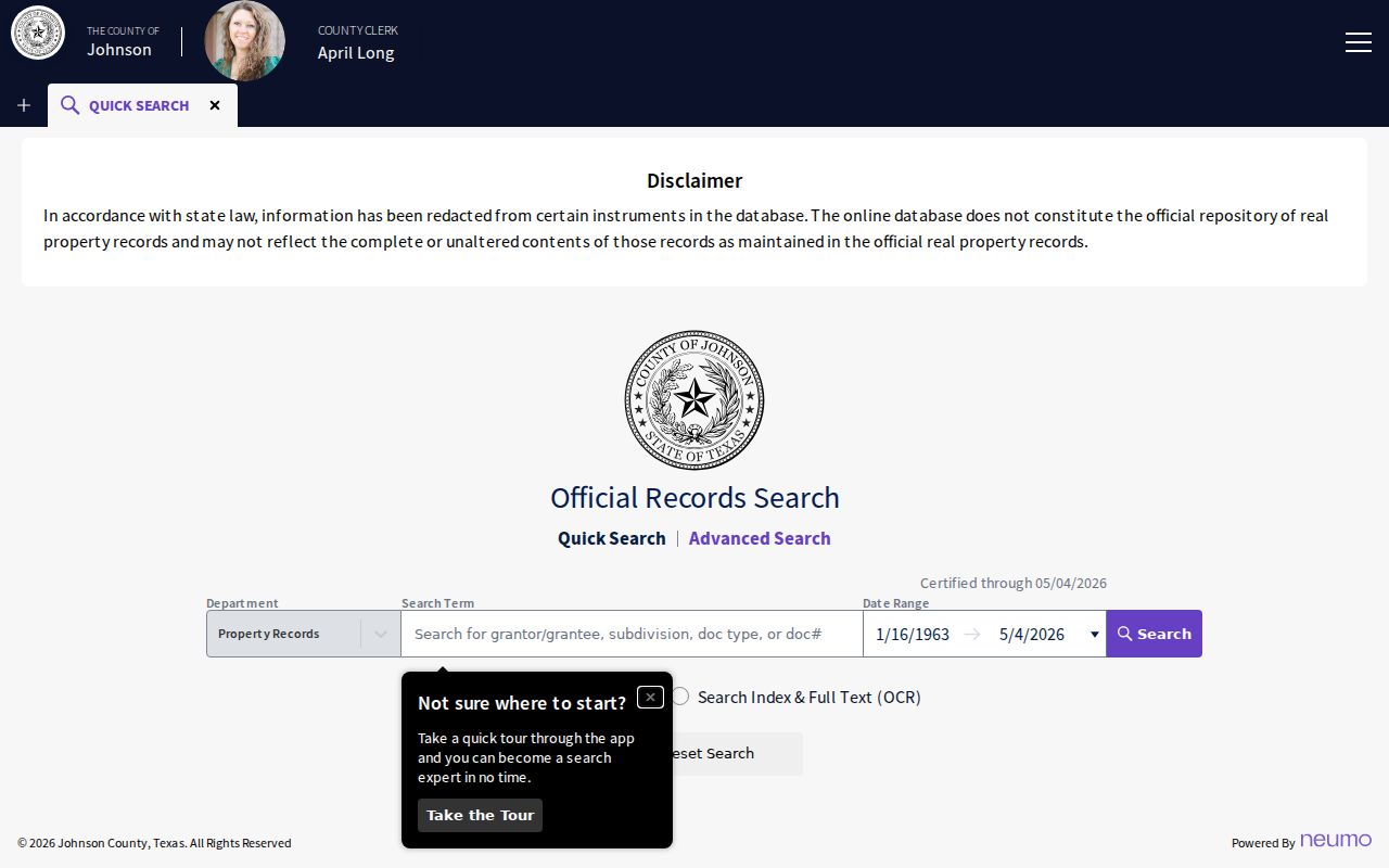
Its result is a starting point for a recorded transfer, not proof that every former owner or occupant lived at the address.
- Copy the current parcel's legal description and owner from JCAD, not only its street number.
- Find the current owner's purchase instrument in the County Clerk index by party name, date range, or legal-description terms.
- Record the grantor, grantee, instrument number, recording date, and the legal description shown on the deed.
- Search the seller as an earlier grantee, then compare the land description before accepting it as the same property.
- Continue backward until the online lead ends, then use clerk terminals, copy requests, or older deed books and microfilm.
- Grantor
- The party conveying an interest in a recorded instrument, often the seller in a deed.
- Grantee
- The party receiving that interest, often the buyer shown in the purchase deed.
- Chain of title
- The sequence of recorded transfers for the same land, checked through the legal description rather than a street number alone.
- Legal description
- The land-identifying wording in a deed, such as a lot and block or survey and abstract reference.
Johnson County Deed Books Beyond the Web
TexasFile reports a full Johnson County index from August 14, 1852 through August 20, 2026 and plat coverage from August 25, 1879 through August 20, 2026. The official search screen does not publish a stable beginning year, so use those dates as a lead and confirm the exact book or year with the County Clerk. The county also says online information is redacted and is not the official repository. A search hit may identify an instrument even when its image, a high-quality copy, or certification requires another route.
The clerk's public-access terminals and written copy or research request are therefore central to a past-residents trail. The County Clerk court section accepts research and copy requests at ccresearch@jocotx.org and is located at Guinn Justice Center, 204 S Buffalo Ave, Cleburne. Its posted hours are Monday through Friday, 8 to 4:30, closed noon to 1. Older records may also require the State Library microfilm route. The local record history includes missing volumes and an 1854-1860 marriage-record theft, which is a reminder to document a gap rather than assume the event never occurred.
The clerk's Property Alert is free and can monitor a selected name or keyword in future real-property filings, including tax liens or releases. It does not search backward, so it supplements rather than replaces a historical deed search.
Johnson County Previous Residents in Directories
Ownership is only one half of a house history. The 1899-1900 Cleburne directory transcription contains a practical address-to-person layer. Its entries may show initials, an occupation, a street or corner address, an employer, “res” for residence, or “bds” for boards. Several names at one address may represent a household, boarders, or a work arrangement. Search the street and nearby intersection as well as the surname, then check the page image before expanding abbreviated text.
Pair the closest directory year with a census schedule. The public federal census reaches 1950 under the 72-year rule. A census can give household, age, and relationship context, while a directory can fill the years between enumerations with an address or occupation. Newspapers add legal notices, obituary detail, and address moves. An entry that is last seen in a directory is not a death date, so close the trail with an obituary, probate, cemetery inquiry, or a later recorded transfer.
- Record spelling, initials, street suffix, residence or boarding notation, and any marital designation from the directory image.
- Check the nearest census year for household and age context, allowing for ward or boundary changes.
- Search the address and name in local newspaper images, then verify OCR hits on the original page.
- Return to the deed chain to keep an occupant, boarder, and owner in separate columns of the evidence log.
The verified collection years, catalog routes, and entry-reading detail belong with the Johnson County city directories. They are useful here as evidence for a single address, not as a substitute for the land record.
Bridge Johnson County Address Changes
An older address may not match a present-day parcel search. Johnson County's 911 system assigns and maintains street-centerline ranges, while plats control lot and street layout, JCAD preserves appraisal geometry, and recorded instruments use legal land descriptions. For unincorporated locations, address assignment follows the driveway along the right-of-way. A city-limit address follows city placement rules. That means an old directory street, a modern 911 address, a ZIP label, and a deed description can all use different but valid identifiers.
Use the county interactive maps and the JCAD GIS viewer as geographic checks. Then compare plats, Sanborn sheets, city directories, newspaper notices, and the 911 centerline before deciding that an address has disappeared. Cleburne's 1898 Sanborn set contains 11 sheets and can show lots, structures, streets, and uses from that period. The 1887 F. G. Blaux land-ownership map is a different kind of source, useful for historical landholders rather than a current parcel card.
Note: An address mismatch may reflect numbering, a boundary layer, or a legal-description change rather than a break in the house-history trail.
Date Johnson County Past Residents with Records
The Cleburne Public Library local-history archive supports a past-residents search after a directory or deed yields a name. The Johnson County Historical Collective's grant-backed project digitizes Cleburne Morning Review and Times-Review material for 1918-1990, although the archive page says more than 20 years of microfilm remained. The larger UNT Johnson County collection has 17,829 items across 17 titles and 16 decades. Search names, streets, and nearby places, but check the image because OCR can misread initials and addresses.
For a trail endpoint, probate can identify estate names and heirs, while obituaries and cemetery records may supply date and family context. Johnson County county-court probate and guardianship records are an official channel, subject to access rules. Do not treat a directory listing, an obituary mention, or a cemetery lead as proof that a person owned a property. The research is stronger when each item is dated and the record's limited role is written beside it.
Even missing records can be useful evidence. Cleburne's Chambers Cemetery was acquired without the sales records, deeds, maps, and ledgers the city expected, and Dallas College research has used LiDAR, ground-penetrating radar, drones, GPS, and GIS to locate unmarked graves. The absence of a ledger calls for cemetery-office, newspaper, map, and obituary work, not an invented ownership history.
Johnson County Previous Residents and Lawful Use
Previous residents research is most reliable when used for house history, family history, estate questions, or local history. It should not be used to track or pressure a living person. Public records can be incomplete, redacted, or held back for safety. The Texas Address Confidentiality Program protects qualifying participants through a substitute mailing address, and protected voter procedures can limit public display of residence information. A public-record request under the Texas Public Information Act does not override those protections.
Save the source, access date, exact address form, document number, and what the item actually proves. If the online trail ends, ask the custodian about an index, public terminal, copy route, library microfilm, or archival holding. Do not copy sensitive identifiers from an image or try to defeat a confidential-address program. Past resident evidence often supports a careful timeline, not a complete account of every person who occupied a property.